Use this image
Can I reuse this image without permission? Yes
Object images on the Ingenium Collection’s portal have the following Creative Commons license:
Copyright Ingenium / CC BY-NC-ND (Attribution-NonCommercial 4.0 International (CC BY-NC 4.0)
ATTRIBUTE THIS IMAGE
Ingenium,
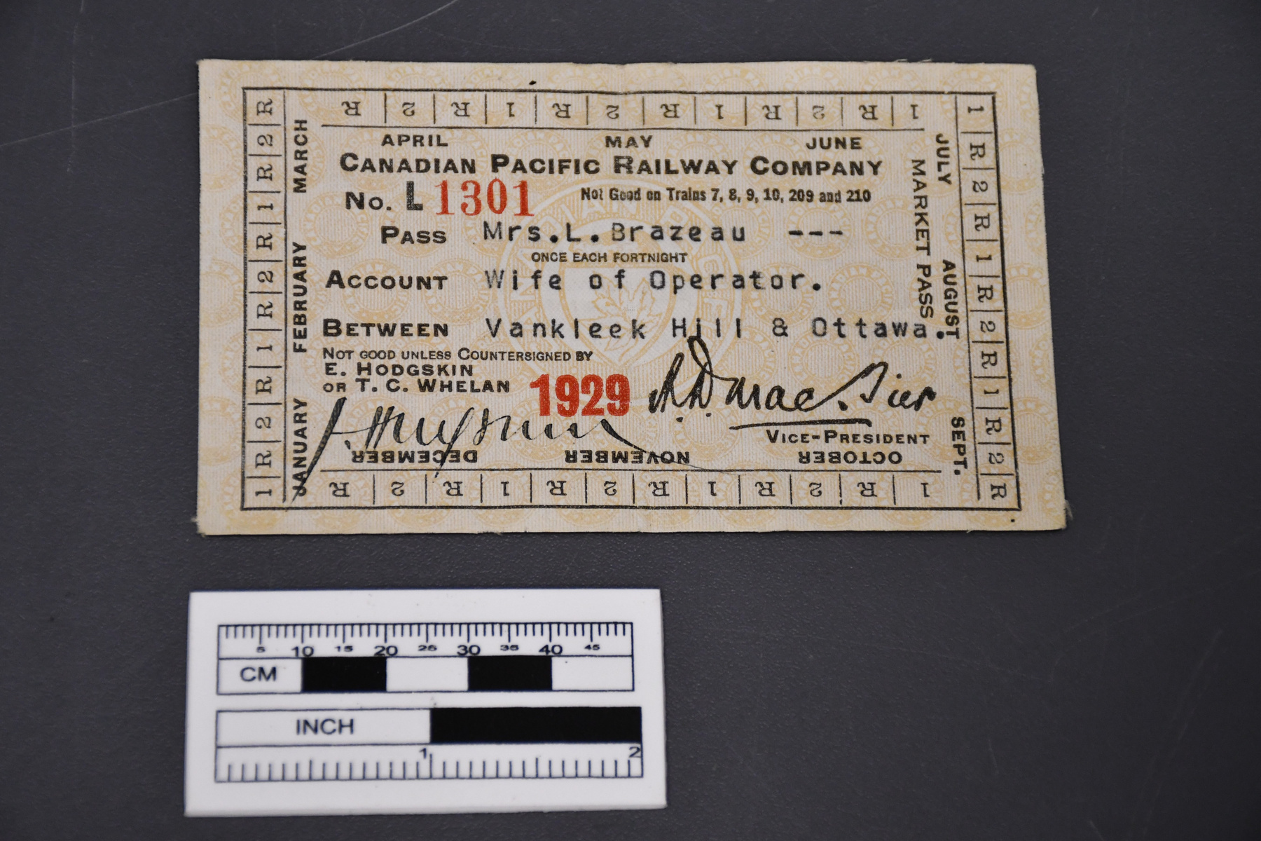
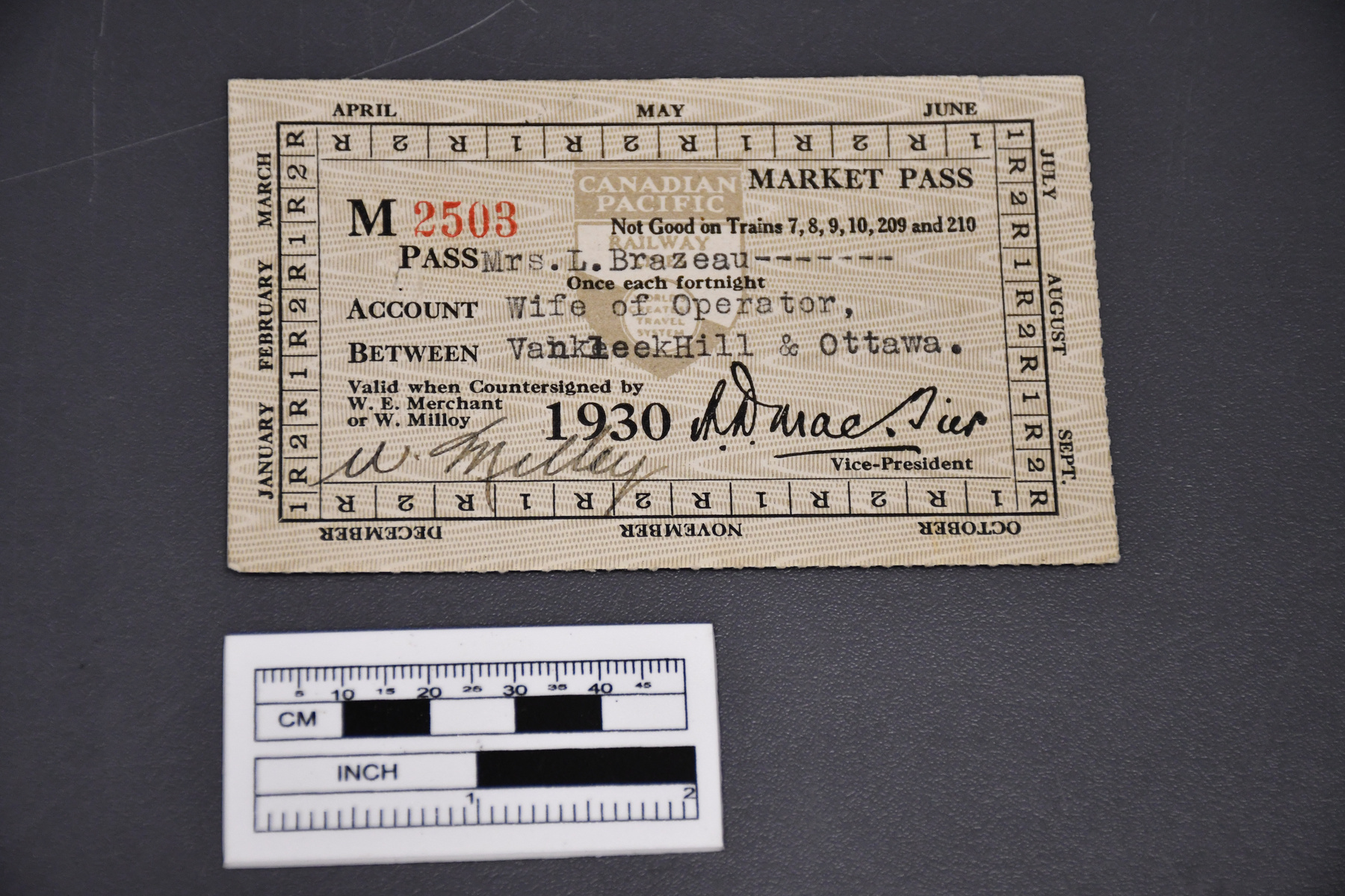
2017.0133.001
Permalink:
Ingenium is releasing this image under the Creative Commons licensing framework, and encourages downloading and reuse for non-commercial purposes. Please acknowledge Ingenium and cite the artifact number.
DOWNLOAD IMAGEPURCHASE THIS IMAGE
This image is free for non-commercial use.
For commercial use, please consult our Reproduction Fees and contact us to purchase the image.
- OBJECT TYPE
- colour/framed
- DATE
- 2004
- ARTIFACT NUMBER
- 2017.0133.001
- MANUFACTURER
- Unknown
- MODEL
- Kananaskis and Bow Valley
- LOCATION
- Unknown
More Information
General Information
- Serial #
- N/A
- Part Number
- 1
- Total Parts
- 1
- AKA
- N/A
- Patents
- N/A
- General Description
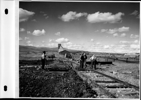
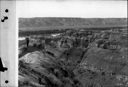
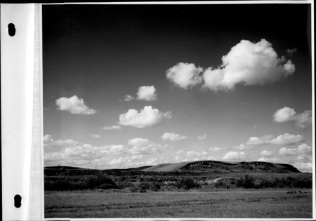
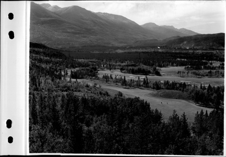
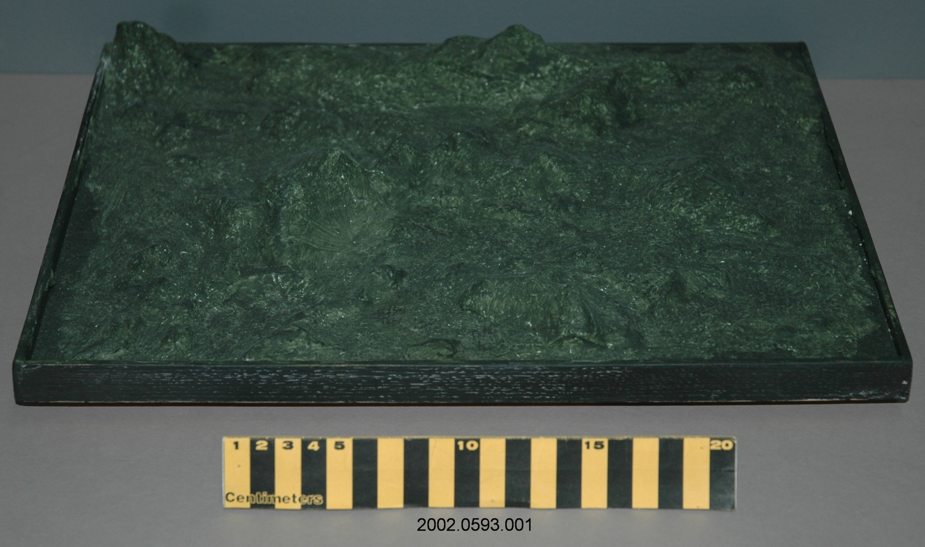
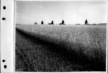
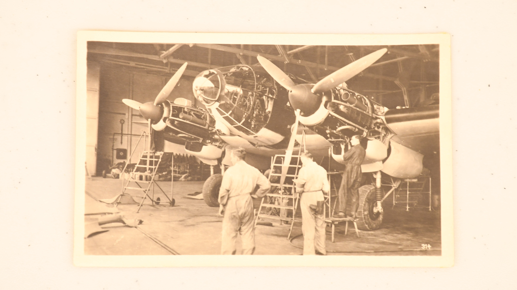
- Print representing terrain elevation of the Kananaskis and Bow Valley region in Alberta.
Dimensions
Note: These reflect the general size for storage and are not necessarily representative of the object's true dimensions.
- Length
- 56.0 cm
- Width
- 102.0 cm
- Height
- N/A
- Thickness
- N/A
- Weight
- N/A
- Diameter
- N/A
- Volume
- N/A
Lexicon
- Group
- Space Technology
- Category
- Commemorative
- Sub-Category
- N/A
Manufacturer
- AKA
- Unknown
- Country
- Unknown
- State/Province
- Unknown
- City
- Unknown
Context
- Country
- Canada
- State/Province
- Unknown
- Period
- Built under contract in 2004 - used until 2017.
- Canada
-
This image was created by the "cross-track interferomatic" mode of the synthetic aperture radar (SAR) flown in 1995 by the Convair 580 aircraft when it was owned by the Canada Centre for Remote Sensing. The radar on CSTMC's Convair 580 aircraft looked to the side of the aircraft, and one of the limitations of this important class of radar is the distortion associated with changes in the terrain elevation. To remove these distortions, CCRS incorporated a new mode which would allow derivation of terrain elevation. The image map of the Kananaskis area of Alberta was created using an extra receive antenna mounted on the right-hand side of the aircraft, allowing ‘cross-track interferometry’, and the derivation of terrain elevation and a ‘geocoded’ map-like product. Cette image a été créé à partir du mode à l'écart latéral interférométrique du radar à synthèse d'ouverture qui a volé en 1995 à l'aide de l'aéronef Convair 580 lorsqu'il appartenait au Centre canadien de télédétection. Le radar sur le Convair 580 dans la collection nationale est orienté sur le côté de l'aéronef et une des limites de ce radar est la distorsion associée avec les changements d'élévation de terrain. Pour éliminer ces distorsions, CCRS a incorporé un nouveau mode qui permet la dérivation de l'élévation de terrain. L'image de la carte de la région de Kananaskis en Alberta a été créé en utilisant une antenne de plus montée sur le côté droit de l'aéronef permettant l'écart latéral interférométrique et la dérivation de l'élévation de terrain ainsi qu'une carte géocodée. - Function
-
Radar image using remote sensing of the Kananaskis and Bow Valley region of Alberta, showing terrain elevation. Image radar utilisant la détection à distance de la région de Kananaskis et Bow Valley en Alberta, démontrant l'élévation du terrain. - Technical
-
During the late eighties and early nineties, the Convair 580 radar facility helped pioneer and demonstrate ‘interferometric’ techniques, now been widely adopted by other radars. With the Convair radars we proved for the first time that relative motion within a scene could be recovered with centimeter accuracy (‘repeat-pass interferometry’). With the extra side-mounted antenna we demonstrated both derivation of terrain elevation (‘cross-track interferometry’), and moving target detection (‘along-track interferometry’). Pendant les années 1980s et début des années 1990s, la faculté de radar Convair 580 est considéré comme étant pionnier en ce qui concerne la démonstration les techniques interférométriques. Aujourd'hui, ces techniques sont adoptées par autres radars. Les radars Convair ont démontré pour la première fois que le mouvement relatif peut être recouvert avec précision en centimètre (interférométrie temporelle). Avec l'ajout d'une autre antenne, CCRS a démontré la dérivation d'élévation de terrain (écart latéral interférométrique) et la détection des cibles mobiles (interférométrie longitudinale). - Area Notes
-
Unknown
Details
- Markings
- Bottom of the print reads in part: " BOW CORRIDOR AND KANANASKIS COUNTRY, ALBERTA, CANADA, MARCH 95 /. CANADA CENTRE FOR REMOTE SENSING AIRBORNE MAPPING RADAR /. 1: 100 000 SCALE " Handwritten on a piece of tape on the back of the frame: " GRAY /. RM 443 "
- Missing
- Appears complete.
- Finish
- Large multicolor print in a black metal frame with a clear glass cover. Along the bottom, the print has black text describing the contents and the representations of the print. All along the perimeter we find a series of numbers large numbers in black as well as a series of small numbers in light blue representing coordinates. The back of the frame has a horizontal metal hanging wire held by two small silver metal brackets. Grande épreuve multicolore avec un cadre en métal noir avec une couverture de verre transparent. Vers le bas, l'image a de l'écriture noire qui décrit les contenus et les représentations de l'épreuve. Tout au long du périmètre on retrouve une série de chiffres noirs ainsi qu'une série de petits chiffres bleu représentant des coordonnées. Le derrière du cadre a un fil en métal horizontal pour accrocher qui est soutenu par deux supports en métal argenté.
- Decoration
- N/A
CITE THIS OBJECT
If you choose to share our information about this collection object, please cite:
Unknown Manufacturer, Print, circa 2004, Artifact no. 2017.0133, Ingenium – Canada’s Museums of Science and Innovation, http://collection.ingeniumcanada.org/en/id/2017.0133.001/
FEEDBACK
Submit a question or comment about this artifact.
More Like This


2017.0133.001